District-profile
![]()
Sangli District :
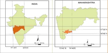
The Sangli district in one of the Southern most district of the state. Sangli lies between 16.46 to 17.10N and 73.42 to 75.4 E latitudes. The geographical area of the district is 8610sq.km. with East-West length 205 km and North-South width is about 96km.
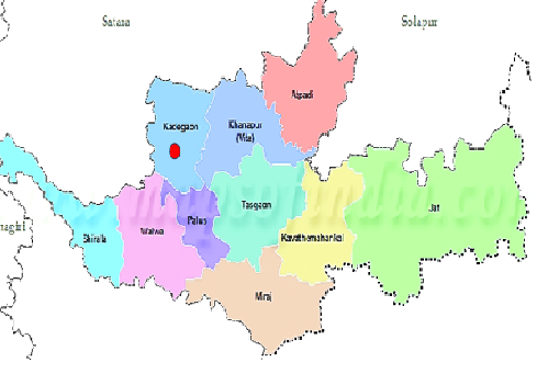
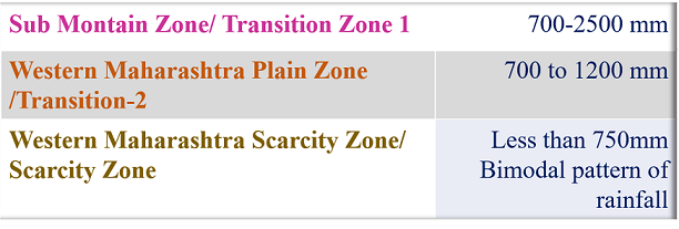
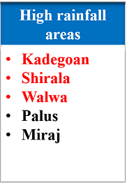
Climate : The district experiences a tropical wet-dry climate characterized by alternating wet and dry spells. The district receives rainfall during South-West monsoon from June to September. The distribution of rainfall is not even all over the district. Western part of the district, in Shirala and Walwataluka area receives heavy rainfall (above 1200mm). While eastern part of the district comes under rain shadow zone. Out of 8610 sq km area of the district about 5684 sq km area fall in a DPAP. In DPAP area receives rainfall between 500mm to 600mm. The annual rainfall received in district ranges from 528.2mm to 1225.8mm with 692.4mm average. It has been observed that about 20% rainfall is received during post-monsoon and by thunder showers in the month of May. The temperature may rise up to 42OC in summer and may fall down to 8OC during winter. The climate in western part of the district especially in Shiralataluka is pleasant.
GEOGRAPHICAL DETAILS
Sangli district is located in the western part of Maharashtra. It is bounded by Satara, Solapur districts to the north, Vijapur district to the east, Kolhapur and Belgum and to the south and Ratnagiri district to the west.
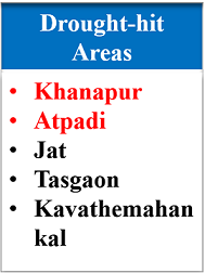
Sangli district is situated in the river basins of the Warna and Krishna river. The physical settings of Sangli district shows a contrast of immense dimensions and reveals a variety of landscapes influenced by relief, climate and vegetation. The climate ranges from the rainiest in the Chandoli (Shirala) region, which has an average annual all of over 4000 mm to the driest in Atpadi and Jath tehsils where the average annual rainfall is about 500 mm. The vegetal cover too varies from the typical monsoon forest in the western parts to scrub and poor grass in the eastern parts.
STATISTICAL DETAILS
Population – 2820575 (2011)
Sr. No.
Sub-Division
Tehsils
Population
Villages
1
Miraj
Miraj
8,54,581
2
Miraj
Tasgaon
2,512401
3
Miraj
KavtheMahankal
1,52,327
4
Jat
Jat
3,28,324
5
Vita
Khanapur
1,70,214
6
Vita
Atpadi
1,38,455
7
Kadegaon
Palus
1,64,909
8
Kadegaon
Kadegaon
1,43,091
9
Walwa
Walwa
4,56,002
10
Walwa
Shirala
1,62,911
Total
5
10
28,20,575
735
AGRICULTURE SCENARIO of- SANGLI District
District’s total area : 8.61 lakh hectares
Uncultivable land : 19%
Fallow land : 8%
Cultivable land : 73%.
Total cropped area of district :7,12,592 hectares.
Out of this 78% is net sown area.
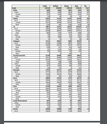
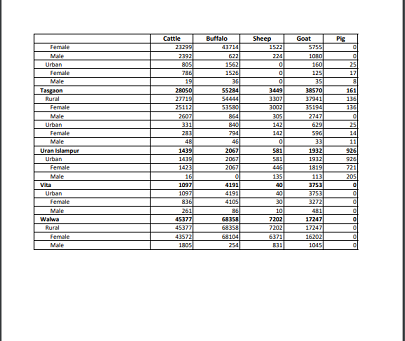
Livestock census of District


Sangli District :
The Sangli district in one of the Southern most district of the state. Sangli lies between 16.46 to 17.10N and 73.42 to 75.4 E latitudes. The geographical area of the district is 8610sq.km. with East-West length 205 km and North-South width is about 96km.
Climate : The district experiences a tropical wet-dry climate characterized by alternating wet and dry spells. The district receives rainfall during South-West monsoon from June to September. The distribution of rainfall is not even all over the district. Western part of the district, in Shirala and Walwataluka area receives heavy rainfall (above 1200mm). While eastern part of the district comes under rain shadow zone. Out of 8610 sq km area of the district about 5684 sq km area fall in a DPAP. In DPAP area receives rainfall between 500mm to 600mm. The annual rainfall received in district ranges from 528.2mm to 1225.8mm with 692.4mm average. It has been observed that about 20% rainfall is received during post-monsoon and by thunder showers in the month of May. The temperature may rise up to 42OC in summer and may fall down to 8OC during winter. The climate in western part of the district especially in Shiralataluka is pleasant.
GEOGRAPHICAL DETAILS
Sangli district is located in the western part of Maharashtra. It is bounded by Satara, Solapur districts to the north, Vijapur district to the east, Kolhapur and Belgum and to the south and Ratnagiri district to the west.
Sangli district is situated in the river basins of the Warna and Krishna river. The physical settings of Sangli district shows a contrast of immense dimensions and reveals a variety of landscapes influenced by relief, climate and vegetation. The climate ranges from the rainiest in the Chandoli (Shirala) region, which has an average annual all of over 4000 mm to the driest in Atpadi and Jath tehsils where the average annual rainfall is about 500 mm. The vegetal cover too varies from the typical monsoon forest in the western parts to scrub and poor grass in the eastern parts.


STATISTICAL DETAILS
Population – 2820575 (2011)
|
Sr. No. |
Sub-Division |
Tehsils |
Population |
Villages |
|
1 |
Miraj |
Miraj |
8,54,581 |
|
|
2 |
Miraj |
Tasgaon |
2,512401 |
|
|
3 |
Miraj |
KavtheMahankal |
1,52,327 |
|
|
4 |
Jat |
Jat |
3,28,324 |
|
|
5 |
Vita |
Khanapur |
1,70,214 |
|
|
6 |
Vita |
Atpadi |
1,38,455 |
|
|
7 |
Kadegaon |
Palus |
1,64,909 |
|
|
8 |
Kadegaon |
Kadegaon |
1,43,091 |
|
|
9 |
Walwa |
Walwa |
4,56,002 |
|
|
10 |
Walwa |
Shirala |
1,62,911 |
|
|
Total |
5 |
10 |
28,20,575 |
735 |
AGRICULTURE SCENARIO of- SANGLI District
District’s total area : 8.61 lakh hectares
Uncultivable land : 19%
Fallow land : 8%
Cultivable land : 73%.
Total cropped area of district :7,12,592 hectares.
Out of this 78% is net sown area.
Livestock census of District

